Thermal mapping is a powerful tool used across industries to detect temperature variations and identify issues like heat loss, equipment overheating, or energy inefficiencies. However, challenges such as sensor drift, low image resolution, and environmental interference often reduce its accuracy and efficiency. Here's how optimization algorithms address these problems:
- Improved Accuracy: Algorithms like Structure from Motion (SfM) and AI-driven tools correct sensor errors, align thermal images with high precision, and enhance data quality. For instance, recalibration methods have reduced temperature errors from ±9°F to ±0.9°F in certain applications.
- Faster Processing: Techniques like surrogate modeling and adaptive gradient methods accelerate data analysis, cutting inspection times by up to 10x and reducing costs by as much as 50%.
- Higher Resolution: Advanced methods enable the creation of detailed 3D models and orthomosaics, improving spatial resolution to less than 4 inches, critical for applications like crop monitoring and infrastructure inspections.
These advancements make thermal mapping more reliable and efficient for industries such as construction, solar energy, and environmental monitoring. Tools like Anvil Labs further streamline workflows by integrating data hosting, processing, and AI analysis into a single platform.

How Optimization Algorithms Improve Thermal Mapping: Key Performance Metrics
How Optimization Algorithms Improve Thermal Mapping
Better Data Accuracy
Optimization algorithms are game-changers when it comes to fixing accuracy issues in thermal imaging. Take low-cost sensors like the FLIR One Pro, which costs around $400. These devices can have calibration errors as high as 36°F near boiling water when used in default settings. In May 2024, researchers at the University of California, Davis introduced the VisTA-SR framework. Using the Nelder-Mead method, this framework recalibrated radiometric temperature parameters, aligning the sensor's readings with precise thermocouple measurements for agricultural crop monitoring. This kind of recalibration is a big step forward for integrating more advanced optimization methods.
Genetic algorithms also play a key role in improving accuracy. A study published in Scientific Reports in September 2024 showed that optimizing a 24-node thermal network for an aerial camera reduced temperature prediction errors to about 1.9°F and slashed the maximum relative error from 33.8% to just 3.1%.
Meanwhile, Generative Adversarial Networks (GANs) like Real-ESRGAN enhance data quality by reconstructing details lost to motion blur, noise, and compression. Multi-modal alignment tools, such as CycleGAN, refine the spatial accuracy of low-resolution thermal imagery by leveraging high-resolution RGB data. This approach addresses challenges in thermal super-resolution.
These improvements not only boost accuracy but also pave the way for faster data processing, which is critical for large-scale applications.
Faster Processing and Analysis
With more accurate data, optimization techniques also speed up processing and analysis. This efficiency is especially important when dealing with thousands of thermal images during industrial inspections. One standout method is surrogate modeling, where deep neural networks replace computationally demanding simulations. This approach enables quick, accurate predictions of thermal properties. For instance, in April 2023, AON3D, a Montreal-based manufacturer, introduced a machine learning-driven thermal optimization system for industrial 3D printing. Their hybrid system, combining numerical methods with statistical modeling, predicts heat flow behavior quickly, helping to prevent print defects.
Other techniques, like mini-batch gradient descent and adaptive methods such as Adam and Nadam, also accelerate convergence. Real-world examples highlight these benefits. In spring 2021, France's Thésée DataCenter implemented Siemens' White Space Cooling Optimization (WSCO), an AI-driven system that autonomously adjusted cooling operations. The result? A Power Usage Effectiveness (PUE) of 1.2 and energy savings of up to 50%. Similarly, in October 2025, Jiangsu New Yangzi Shipbuilding combined CFD simulation data with machine learning models to forecast temperatures in LNG storage tanks. This helped manage thermal conditions during maritime transportation.
Higher Spatial and Temporal Resolution
Building on improvements in accuracy and speed, optimization techniques also enhance spatial and temporal resolution in thermal mapping. Structure-from-Motion (SfM) methods, for example, align overlapping thermal images to create dense 3D point clouds and high-resolution orthomosaics. With UAV-based thermal remote sensing, spatial resolutions can reach less than 4 inches, a massive improvement compared to satellite imagery like Landsat 8, which offers resolutions of about 328 feet. However, halving the ground sampling distance typically increases flight time by 3.55 times.
OcTree data structures take this further by segmenting thermal point clouds into voxels, enabling multi-resolution mapping. At Ghent University, researchers found that using initial thermal camera positions derived from aligned RGB images significantly improved thermal image alignment. As Wouter H. Maes from the Department of Forest and Water Management at Ghent University noted:
"Using initial thermal camera positions derived from RGB image alignment significantly improved thermal image alignment in all datasets."
Dynamic corrections also ensure temporal consistency by compensating for temperature drift and changing weather conditions during data collection. For instance, swath-based normalization can reduce inconsistencies caused by flight direction relative to wind, achieving an RMSE of about 2.2°F compared to on-site measurements. Additionally, applying geometric corrections, such as the Brown-Conrady model for lens distortion, and adjusting for ambient temperature changes ensure the reliability of thermal data collected over time.
sbb-itb-ac6e058
How to Implement Optimization Algorithms for Thermal Mapping
What to Consider Before Implementation
Before diving into optimization algorithms, it's important to assess a few key factors. The choice of optimization method largely depends on the nature of your data. For smoother, continuous surfaces, derivative-based methods are a good fit. On the other hand, evolutionary algorithms work better for noisier data. As Brian Turton from Airbus Defence and Space points out:
"The best solution depends on the 'surface' you are optimising and the number of dimensions."
Data quality is another critical aspect. Machine learning–driven optimization relies heavily on robust, high-quality training datasets to create surrogate models that can replace resource-heavy simulations. Additionally, consider whether you're tackling a single-objective or multi-objective problem. For example, in August 2025, researchers Wolfgang Rannetbauer from voestalpine Stahl GmbH and Simon Hubmer from Johannes Kepler University Linz successfully applied multi-objective optimization algorithms like NSGA-II to optimize High-Velocity Oxygen Fuel (HVOF) thermal spraying. Their approach balanced coating quality with cost-efficiency.
Lastly, ensure your drone-mounted thermal cameras provide data in formats compatible with your processing tools. Ideally, this data should include GPS-tagged coordinates to enable precise stitching of thermal images.
Step-by-Step Workflow for Thermal Data Processing
Start by defining your goals, such as reducing temperature prediction errors, and outline any hardware limitations. Field data collection comes next. Use drone-mounted thermal sensors to capture images, ensuring they are recorded in supported color palettes like "Iron-bow" - currently the only supported option.
Once you've gathered the data, upload the thermal images to a centralized hub for processing. Verify that all data points are accurately mapped, which typically appear as yellow dots in project overviews. Depending on your needs, you can then process the data to create either 2D orthomosaic maps for flat areas or 3D models for complex infrastructure requiring volumetric analysis. To confirm the reliability of your optimized settings, conduct physical trials or use cross-validation methods. Using a dedicated platform can simplify and streamline this entire workflow.
Using Anvil Labs for Thermal Mapping

Anvil Labs provides an all-in-one platform tailored for managing thermal imagery and other spatial data types. It offers tools for hosting, processing, and analyzing thermal data, all accessible across devices. With built-in annotation and measurement tools, you can directly mark anomalies on 3D models or orthomosaics and securely share your findings with your team.
The platform also integrates AI analysis tools and task management systems, making it easier to transition from data collection to actionable insights. Pricing starts at $49 per project for basic hosting, sharing, and management. The Asset Viewer plan, which includes collaboration features, is available at $99 per month. For additional data processing, the cost is $3 per gigapixel. By centralizing all your thermal data and analysis needs, Anvil Labs eliminates the hassle of switching between multiple tools, keeping everything in one place for seamless workflow management.
Industrial Applications of Optimized Thermal Mapping
Construction and Infrastructure Monitoring
Thermal mapping has completely changed how we monitor the integrity of buildings and infrastructure. With AI-powered algorithms, detecting structural issues like insulation gaps, moisture intrusion, or thermal bridging has become faster and far more reliable, achieving fault detection rates of over 95%. What used to take days of manual inspections - often requiring risky climbs onto roofs or scaffolding - can now be completed in mere hours using drones, all while keeping operators safe.
One standout advancement is 3D thermal reconstruction, which uses Structure-from-Motion (SfM) techniques to create detailed 3D models from thermal images. This approach makes it easier to identify areas of energy loss. For instance, research from the University of Castilla-La Mancha in June 2023 highlighted how an automatic temperature correction method, combined with an outlier filtering algorithm, reduced the error in building transmittance (U-value) calculations from 94% to just 11%.
Additionally, advanced signal processing can detect structural flaws as small as 0.075 inches, which would otherwise go unnoticed. To maximize accuracy, technicians should adjust emissivity settings to match the inspected material (e.g., 0.95 for concrete) and schedule flights during early morning or late evening when temperature differences are most pronounced. These evolving technologies demonstrate just how versatile thermal mapping can be across various industrial applications.
Environmental Monitoring
Thermal mapping isn’t just for construction - it’s also transforming how we monitor the environment. With centimeter-level precision, thermal mapping achieves a level of accuracy that satellite imaging simply can’t match. A great example is the FLAME 3 dataset, developed by researchers Bryce Hopkins and Fatemeh Afghah. Using radiometric thermal UAV imagery, they captured georeferenced thermal data every 3–5 seconds, enabling precise tracking of wildfire spread and energy release. This kind of data supports quicker, more effective intervention strategies.
Beyond precision, drones equipped with thermal sensors offer a safer way to monitor dangerous environments. They allow scientists to observe active wildfire zones or hazardous material spills without putting themselves in harm’s way. Thermal mapping even plays a role in wildlife conservation, helping researchers track animal activity in dense vegetation without disturbing their habitats. AI streamlines the analysis of the large datasets collected during these missions, offering fault detection rates over 95% and completing surveys up to ten times faster than traditional methods.
Equipment and Asset Management
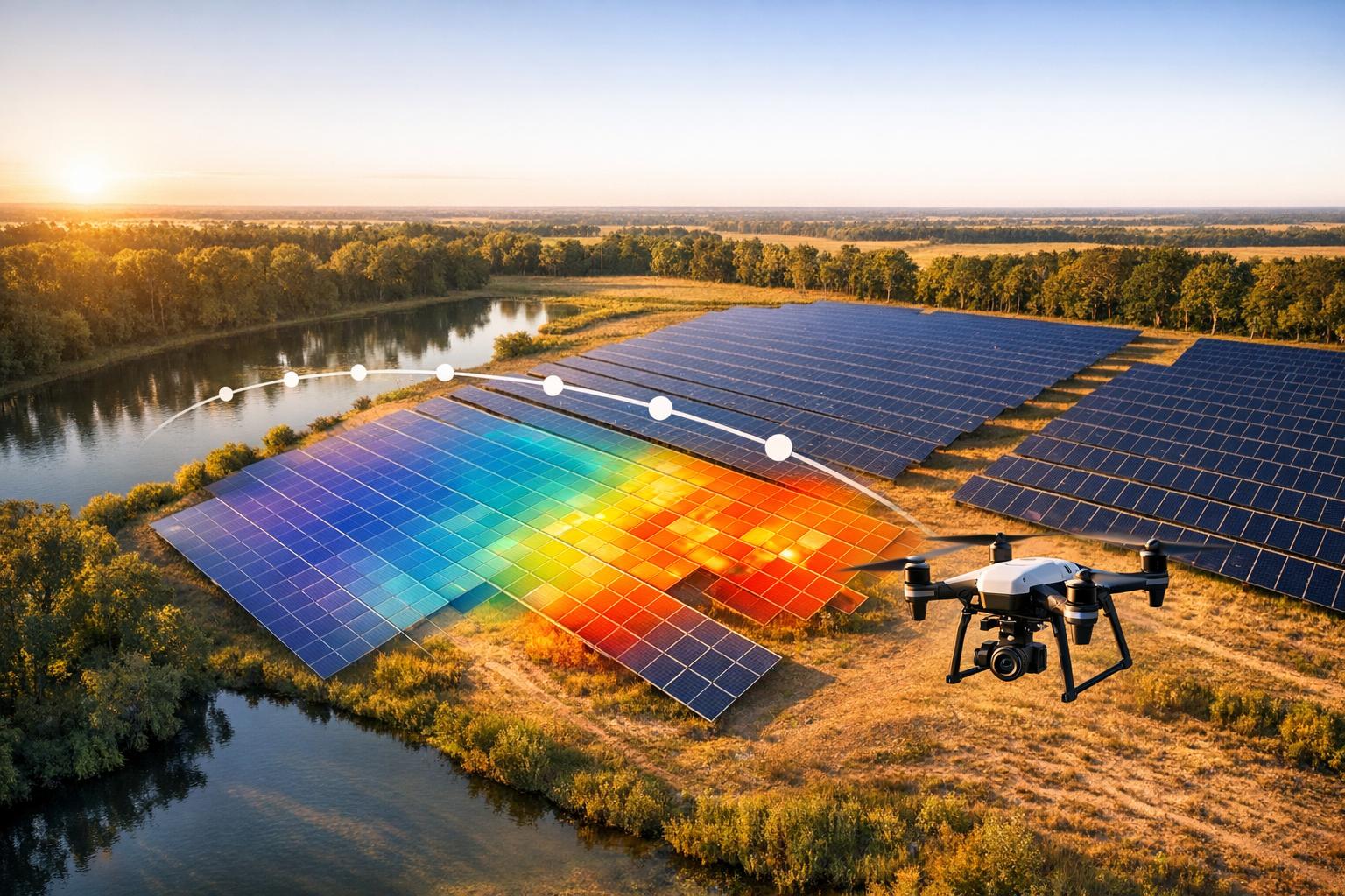
Thermal mapping also proves invaluable in managing industrial assets. It’s a powerful tool for early fault detection in facilities, identifying overheating in components like bearings or electrical connections, as well as spotting insulator damage or gradual machinery wear. In solar farms, optimization algorithms help pinpoint issues like hotspots, faulty cells, diode failures, and string outages, all while adhering to IEC standards.
Georeferenced 3D models and orthomosaics generated through thermal mapping make it easier for maintenance teams to locate failing components with pinpoint accuracy, reducing downtime. High-quality thermal sensors - offering resolutions of at least 640×512 pixels and thermal sensitivity of ≤50 mK - capture the fine details needed to detect subtle problems. These tools ensure that maintenance is not only faster but also more precise, keeping operations running smoothly.
Conclusion
Summary of Benefits
Optimization algorithms are changing the game for thermal mapping. By addressing sensor instability, they’ve improved temperature reading accuracy from a shaky ±9°F during flight to a much steadier ±0.9°F under stable conditions. They also power AI-driven fault detection with over 95% accuracy, dramatically cutting inspection times - sometimes by as much as tenfold. These algorithms handle the surge in data from higher-resolution mapping, striking a balance between delivering detailed insights and keeping operations practical.
With centimeter-level precision, they’re invaluable for monitoring environments and identifying equipment issues like overheating. This means maintenance teams can act on clear, actionable data. As Viper Imaging highlights:
Automated thermal analysis algorithms can quickly analyze large datasets, ensuring consistent quality control and reducing the likelihood of faulty products reaching the market.
Future of Thermal Mapping
Looking ahead, thermal mapping is poised for even greater advancements. Real-time edge processing and collaborative thermal swarms could revolutionize how we respond to dynamic events like hazardous material spills or wildfires. Integrating these systems with IoT and predictive analytics will enable maintenance teams to spot potential failures before they happen. Meanwhile, cutting-edge technologies like Generative Adversarial Networks (GANs) are opening doors to designing new thermal materials.
Continuous mapping frameworks are another exciting development, offering real-time performance data and potentially eliminating the need for disruptive, periodic re-mapping. Ultra-high resolution mapping, capable of sub-millimeter Ground Sampling Distance, is set to expand possibilities in fields like precision agriculture and early plant disease detection. Tools like Anvil Labs, which combine thermal imagery with 3D models and spatial analysis, are making these advancements more accessible and practical for industries worldwide.
Introduction to thermal mapping with UAVs
FAQs
How do optimization algorithms improve the precision of thermal mapping?
Optimization algorithms play a key role in improving the accuracy of thermal mapping by fine-tuning how data is processed, calibrated, and analyzed. Methods such as gradient descent are applied to thermal imagery captured by UAVs, ensuring temperature readings are more precise and anomalies are easier to spot.
By aligning thermal data more closely with actual conditions, these algorithms make it possible to detect even small temperature differences. This capability is especially useful for tasks like energy audits, industrial inspections, and monitoring environmental changes.
What are the main advantages of faster processing in thermal mapping?
Speeding up thermal mapping processes brings some clear advantages. For starters, it can cut inspection times by as much as 75%, which means less time spent on the job and fewer resources used. This efficiency boost doesn’t just save time - it also reduces costs.
Another big plus? Real-time data. With instant access to thermal insights, teams can make quick, informed decisions on the spot. This is especially helpful in high-pressure or risky situations, where every second counts. Plus, faster issue detection lowers operational risks, making the entire process safer and more reliable.
How does higher spatial resolution benefit industries using thermal mapping?
Higher spatial resolution allows for creating thermal maps with exceptional detail, making it possible to spot even the smallest temperature changes. This level of precision means industries can catch potential problems early, which improves maintenance routines, raises safety levels, and streamlines operations.
With access to finer details, businesses can make smarter decisions, cut down on downtime, and use resources more efficiently. The result? Lower costs and better overall performance.
