Drone photogrammetry and LiDAR are two leading technologies for creating 3D models, but they excel in different scenarios. Here's a quick breakdown:
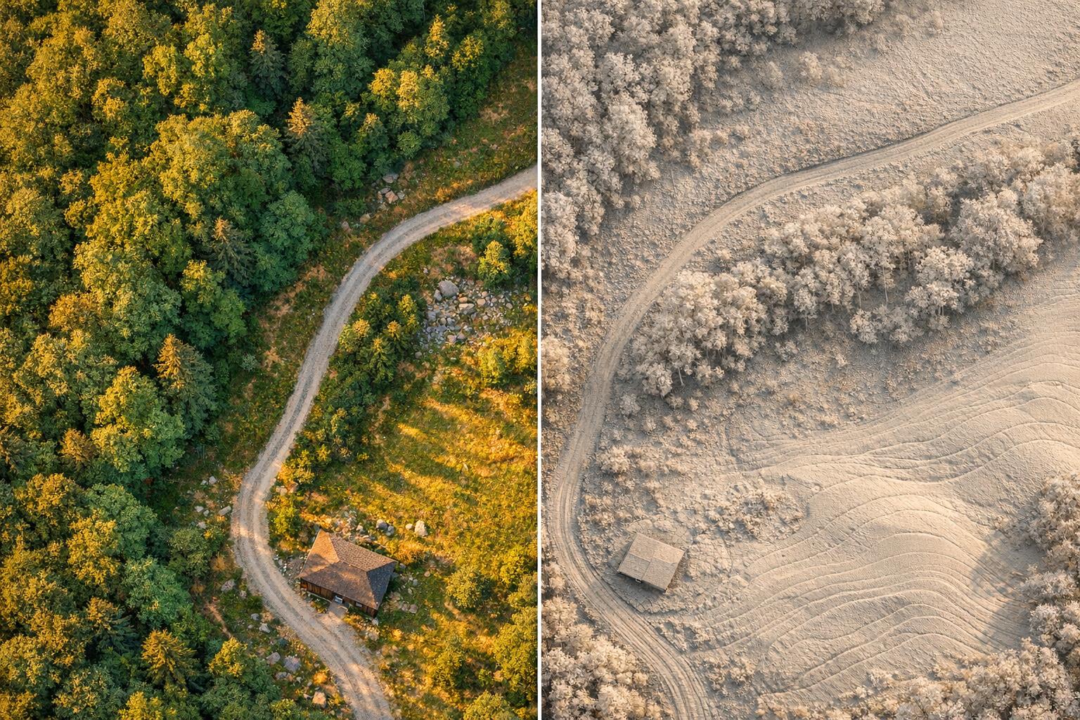
- Photogrammetry uses overlapping images to create detailed, photorealistic 3D models. It's cost-effective and ideal for open, well-lit areas but struggles with dense vegetation and low-light conditions.
- LiDAR uses laser pulses to directly measure distances, offering high accuracy and the ability to penetrate vegetation. It works in poor lighting but comes at a higher cost.
Key Differences:
- Accuracy: LiDAR generally provides better vertical precision (0.4–1.2 in) compared to photogrammetry (0.8–1.6 in).
- Lighting: Photogrammetry relies on daylight, while LiDAR works in darkness.
- Vegetation: LiDAR penetrates vegetation; photogrammetry only captures surface details.
- Cost: Photogrammetry setups are cheaper ($20,000–$30,000) than LiDAR systems ($50,000–$350,000).
Quick Comparison:
| Feature | Drone Photogrammetry | Drone LiDAR |
|---|---|---|
| Horizontal Accuracy | 0.4 in (1 cm) | 0.4–0.8 in (1–2 cm) |
| Vertical Accuracy | 0.8–1.6 in (2–4 cm) | 0.4–1.2 in (1–3 cm) |
| Lighting Dependency | Requires daylight | Works in darkness |
| Vegetation Performance | Poor (captures canopy only) | Excellent (penetrates ground) |
| Cost | $20,000–$30,000 | $50,000–$350,000 |
Bottom Line: Photogrammetry is best for visual detail in open environments, while LiDAR excels in complex, vegetated, or low-light areas. Combining both can offer the most accurate and detailed results.

Drone Photogrammetry vs LiDAR Accuracy Comparison Chart
Key Accuracy Metrics for Drone Photogrammetry and LiDAR
Horizontal and Vertical Accuracy
When it comes to accuracy, drones measure in two main ways: horizontally (X, Y) and vertically (Z). Both photogrammetry and LiDAR excel in horizontal accuracy, but they differ significantly when it comes to vertical measurements.
Photogrammetry relies on overhead imagery, which can limit its vertical precision. Emily Loosli from Wingtra explains:
"Photogrammetry offers excellent horizontal accuracy down to 1 cm, but due to the predominantly nadar nature of capture, the vertical accuracy will be half to a third as good."
Photogrammetry typically achieves horizontal accuracy around 0.4 inches (1 cm) and vertical accuracy between 0.8–1.6 inches (2–4 cm). LiDAR, on the other hand, delivers consistent precision in both directions, with vertical accuracy ranging from 0.4–1.2 inches (1–3 cm). This consistency is partly due to LiDAR's active laser system, which operates independently of lighting conditions, unlike photogrammetry.
| Accuracy Type | Drone Photogrammetry | Drone LiDAR |
|---|---|---|
| Horizontal | Down to 0.4 in (1 cm) | Down to 0.4–0.8 in (1–2 cm) |
| Vertical | 0.8–1.6 in (2–4 cm) | 0.4–1.2 in (1–3 cm) |
| Lighting Dependency | High; requires daylight | None; works in darkness |
| Vegetation Performance | Poor; captures canopy only | Excellent; penetrates ground |
This table highlights how LiDAR maintains an edge in challenging conditions, offering reliable accuracy even in poor lighting or dense vegetation.
Point Density and Data Resolution
Point density - how many measurements are taken per square foot or square meter - plays a critical role in model detail. While higher density generally means more detail, the type of detail varies between photogrammetry and LiDAR.
Photogrammetry can generate dense point clouds, sometimes reaching up to 325 points/ft² (3,500 points/m²) under optimal conditions. LiDAR, depending on the system and flight setup, produces a range of 58–600+ points/ft² (625–2,000+ points/m²). However, there's a key difference: photogrammetry relies on inferred data from images, while LiDAR points are direct geometric measurements.
A real-world example from January 2019 shows this difference. Skeye B.V. conducted a survey of a breakwater in Scheveningen, Netherlands, using both methods. Photogrammetry achieved a finer grid resolution of 0.8 inches (2 cm) compared to LiDAR's 2 inches (5 cm). However, when it came to vertical absolute accuracy, photogrammetry reached 0.16 inches (4 mm) using leveling-based checkpoints, while LiDAR recorded 0.8 inches (20 mm). This underscores how resolution and accuracy, though related, are distinct metrics.
The density of points directly impacts the detail and reliability of models, which is crucial for tasks like industrial assessments.
Relative vs. Absolute Accuracy
To make drone data truly useful, you need to understand two types of accuracy: relative and absolute.
- Relative accuracy focuses on internal consistency, like measuring distances or volumes on a single site.
- Absolute accuracy measures how well the model aligns with real-world coordinates, such as NAD83 or NAVD88.
Chara Chatzikyriakou from Skeye B.V. explains:
"The magnitude of the absolute accuracy is highly dependent on the quality of the measurements of the check point."
Absolute accuracy is critical for projects that integrate drone data with CAD designs, property boundaries, or historical surveys. On the other hand, relative accuracy is often enough for tasks like internal monitoring or tracking changes over time.
A study by the Idaho Transportation Department between April 2016 and October 2018 illustrates these concepts. On US-30 near Georgetown, aerial LiDAR achieved a vertical RMSE of 1.2 inches (3.14 cm) across 545 sample points. Mobile-terrestrial LiDAR outperformed it with 0.29 inches (0.732 cm) on pavement. UAV photogrammetry, using a 0.6-inch (1.5 cm) ground sampling distance, produced RMSE values ranging from 0.75 to 6.7 inches (1.9 to 17.1 cm), depending on the quality of ground control.
These findings highlight the importance of choosing the right tool based on the specific demands of your project.
Performance Comparison: Drone Photogrammetry vs. LiDAR
Comparison Table: Key Performance Metrics
When deciding between photogrammetry and LiDAR, it’s essential to see how they measure up across several key areas:
| Feature | Drone Photogrammetry | Drone LiDAR |
|---|---|---|
| Sensor Type | Passive (camera-based) | Active (laser-based) |
| Visual Output | Photorealistic 3D models & orthophotos | Dense point clouds with limited color detail |
| Processing Time | Slower due to image stitching | Faster |
| Cost | Lower (approximately $20,000–$30,000 for high-end setups) | Higher (approximately $50,000–$350,000) |
In a real-world test conducted at the Scheveningen Breakwater site, LiDAR processed data in just 4 hours, while photogrammetry required 8 hours to complete. This highlights LiDAR's edge in processing speed. These details help clarify the unique advantages each technology offers.
Strengths of Drone Photogrammetry
Photogrammetry shines in projects requiring high-resolution visuals in well-lit, open environments. It’s widely used for tasks like construction monitoring, asset inspections, and creating photorealistic 3D models that help stakeholders better visualize a site.
This method delivers impressive results, achieving up to 3,500 points per square meter and ground sampling distances as fine as approximately 1.6 cm per pixel. Such precision makes it ideal for detecting small surface features. Additionally, photogrammetry’s lower equipment costs (compared to LiDAR) and user-friendly setup make it a go-to choice for industries like agriculture or construction, especially on cleared or open sites.
However, photogrammetry does have its limitations. It depends heavily on consistent daylight and struggles in areas with shadows or low-texture surfaces. Dense vegetation, even something as simple as thick grass, can obscure critical ground details. This is where LiDAR steps in to fill the gaps.
Strengths of LiDAR
LiDAR’s capabilities stand out in challenging environments. As an active sensor, it uses laser pulses to operate effectively in low-light or even completely dark conditions. Its ability to penetrate vegetation allows it to capture the bare earth beneath, making it invaluable for topographic surveys in forested or overgrown areas.
LiDAR is particularly reliable in regions with dense vegetation, where photogrammetry might falter. Chara Chatzikyriakou from Skeye B.V. explains:
"In a vegetated area or for surveying narrow structures LiDAR is undoubtedly a more suitable solution."
LiDAR consistently delivers vertical accuracy in the range of 1–3 cm, even on complex terrain. For instance, during the 2025 Indiana Drones football stadium project, which spanned 20 acres, a DJI M600 equipped with LiDAR and an Emlid Reach RS2 RTK base station achieved approximately 2 cm precision. This project also showcased LiDAR’s ability to capture intricate overhung structures. Interestingly, photogrammetry was used alongside LiDAR to provide detailed surface textures, highlighting how the two methods can complement one another.
The main tradeoff with LiDAR is its higher cost. Additionally, while it produces dense point clouds (typically between 100 and over 1,000 points per square meter), these lack the rich visual detail of photogrammetric models unless paired with RGB cameras. Despite this, its performance in difficult conditions makes it a powerful tool for many applications.
Use Cases and Applications in Industrial Site Management
When to Use Drone Photogrammetry
Drone photogrammetry shines in scenarios where capturing visual details and textures is crucial. This makes it a go-to solution for tasks like roof inspections, analyzing facade cracks, or identifying color-coded assets across large facilities. It’s particularly effective in open, well-lit environments such as oil and gas plants, construction sites, and mining operations.
Take the example of IATEC Plant Solutions Inc., which, in June 2016, used a DJI Inspire 1 drone and Pix4D software to survey a sprawling 750,000-square-meter Petrobras gas treatment plant in Brazil. Over just three days, the team captured 2,588 images across 10 sub-areas. They then imported the resulting 3D point cloud into Autodesk Navisworks to compare the as-built conditions with existing design models - uncovering discrepancies far faster than traditional laser scanning methods.
For applications like volumetric analysis in mining or stockpile management, photogrammetry delivers accuracy that rivals LiDAR. With RTK or PPK technology, it can achieve horizontal accuracies of ±1–3 cm and vertical accuracies of ±2–4 cm. This level of precision is often more than adequate for many industrial needs.
However, when photogrammetry reaches its limitations, LiDAR steps in.
When to Use LiDAR
LiDAR is the better choice for more challenging survey conditions. For example, in areas with dense vegetation, limited clearance, or forested regions, LiDAR’s laser pulses can penetrate the canopy to capture details of the ground - something photogrammetry simply can’t do [4, 5]. It’s also the preferred tool for mapping narrow structures like power lines, cables, and pipes, which photogrammetry software often struggles to reconstruct accurately [3, 4].
Another advantage of LiDAR is its active sensing capability, which allows it to collect reliable data even in low-light or completely dark conditions. This makes it invaluable for night surveys or areas with heavy shadows [2, 4].
"In a vegetated area or for surveying narrow structures LiDAR is undoubtedly a more suitable solution."
– Chara Chatzikyriakou, Project Manager, Skeye B.V.
These strengths make LiDAR an essential tool for specific scenarios, but the real magic happens when it’s used alongside photogrammetry.
Combining Photogrammetry and LiDAR
By integrating photogrammetry and LiDAR, industrial site managers can take advantage of both technologies’ strengths. This hybrid approach creates highly detailed site models, combining LiDAR’s geometric accuracy with photogrammetry’s rich textures. The result? Digital twins and Building Information Models (BIM) that offer both structural precision and photorealistic detail.
For instance, during the 2025 Indiana stadium project, a DJI M600 equipped with LiDAR and an Emlid Reach RS2 RTK base station achieved approximately 2 cm accuracy across 20 acres. At the same time, photogrammetry using a DJI Inspire 2 provided textured meshes for surface assessments. Similarly, in 2019, the USGS used a Leica CountryMapper dual-sensor system in Colorado to collect 8-inch resolution orthoimagery and LiDAR data at 2.9 points per square meter in a single flight - meeting both topographic and imagery needs.
Platforms like Anvil Labs make this combined workflow even more efficient by hosting both LiDAR point clouds and photogrammetric models in one place. This unified approach simplifies data management, enabling teams to overlay datasets or switch between them with ease. It ensures that all stakeholders work from a shared spatial reference, streamlining analysis and decision-making processes.
sbb-itb-ac6e058
Best Practices for Achieving High Accuracy in 3D Models
Ground Control Points and RTK/PPK
When it comes to achieving precision in 3D modeling, the role of Ground Control Points (GCPs) and positioning technologies like RTK (Real-Time Kinematic) and PPK (Post-Processed Kinematic) cannot be overstated. Photogrammetry depends on a dense distribution of GCPs to avoid distortion, especially across large survey areas. Without sufficient GCP coverage, accuracy drops significantly in areas outside the perimeter. In contrast, LiDAR uses fewer GCPs since it relies more heavily on the drone's internal IMU and GNSS systems for positioning accuracy.
RTK and PPK are game-changers for reducing errors. RTK provides real-time corrections but requires uninterrupted communication, while PPK logs data for post-flight corrections, making it more dependable when connection issues arise. For example, during a 2022 survey of the Scheveningen breakwater, photogrammetry achieved a vertical accuracy of 4 mm using 26 GCPs, compared to LiDAR's 20 mm accuracy.
"Because it is more reliable, PPK is often suggested as a back-up for RTK that fails." - Emily Loosli, Wingtra
By incorporating GCPs into photogrammetry workflows, absolute position errors can improve from 0.12 m to 0.05 m, and Root Mean Square Error (RMSE) can drop from 0.03 m to 0.01 m. Even with RTK/PPK-enabled drones, independent checkpoints should be included to validate the final model's accuracy. These steps are critical for meeting the precision standards required in industrial site management.
Data Processing and Quality Assurance
Collecting high-quality data is just the beginning - processing and quality assurance are equally important to maintain accuracy. For photogrammetry, high image overlap (at least 80%) is essential for seamless stitching. LiDAR datasets, on the other hand, require a denoising process to eliminate "ghost points" caused by reflective surfaces or atmospheric interference.
In a 2019 U.S. Geological Survey project in Colorado, a Leica Geosystems CountryMapper was used at an altitude of 3.6 km. The LiDAR survey achieved a point density of 3.1 to 3.7 points per square meter, with intraswath precision better than 1 cm. Overlapping swaths had root mean square differences of ≤ 0.04 m in 99% of rural areas, demonstrating excellent calibration.
Validation is key. Use independent checkpoints that were not part of the initial data processing to ensure unbiased accuracy assessments. For LiDAR, interswath analysis - comparing overlapping areas of adjacent swaths - can measure the calibration quality directly. These meticulous protocols ensure the reliability of the final model.
Flight planning also impacts accuracy. Maintaining a consistent altitude (terrain following) ensures uniform Ground Sampling Distance (GSD) and point density. Environmental factors play a role as well. Photogrammetry requires steady daylight and minimal shadows, while LiDAR can operate at night but is sensitive to conditions like rain, fog, and reflective surfaces such as glass or water.
Using Platforms like Anvil Labs
Once your 3D data is ready, managing it effectively is just as important as creating it. Platforms like Anvil Labs provide a centralized space to host 3D models, LiDAR point clouds, and orthomosaics. These platforms allow users to annotate, measure, and securely share data across devices, making collaboration seamless and efficient.
For industrial site management, having a single hub eliminates the confusion of juggling multiple file versions and scattered datasets. Whether you're working with photogrammetry, LiDAR, or both, a centralized platform ensures that the precision you've worked hard to achieve translates into actionable insights for your projects.
Drone LiDAR vs Photogrammetry | Epic Stadium 3D model
Conclusion: Choosing the Right Technology for Your Needs
Deciding between drone photogrammetry and LiDAR comes down to aligning the tool with your specific project needs. For open areas where visual detail is key, photogrammetry provides detailed 3D models at a much lower cost. On the other hand, LiDAR excels in dense vegetation, rugged landscapes, or situations requiring high vertical accuracy. Its ability to penetrate canopy gaps and function in low-light conditions often makes it the go-to option in such scenarios. Costs and integration needs also play a significant role in making the final decision.
"For professional pilots and surveyors, the choice between LiDAR vs photogrammetry isn't about which is better overall, but which fits your site, budget, and accuracy needs." - Kristaps Brass, Product Owner, SPH Engineering
The choice ultimately depends on the specific measurement challenges and environmental conditions you're dealing with. Budget is another key factor to weigh. Photogrammetry solutions are relatively affordable, costing a few thousand dollars, while LiDAR systems can climb into the hundreds of thousands. However, combining both technologies can strike a balance between cost and performance. Take, for example, the 2025 Indiana stadium survey. By using a DJI M600 equipped with LiDAR and a DJI Inspire 2 for photogrammetry, the team achieved approximately 2 cm precision while capturing the visual details engineers needed for renovations. This hybrid approach merged LiDAR's geometric accuracy with photogrammetry's rich textures, creating a comprehensive digital twin.
Once data collection is complete, managing it effectively becomes essential. A unified platform like Anvil Labs ensures that 3D models, LiDAR point clouds, and orthomosaics are organized and accessible, turning precise data into actionable insights.
FAQs
Which is better for my project: drone photogrammetry or LiDAR?
Choosing between drone photogrammetry and LiDAR boils down to your project's specific requirements, such as accuracy, site conditions, and budget constraints.
LiDAR is perfect for projects that demand high precision, especially in tough environments like dense forests or uneven terrain. With vertical accuracy ranging from 1–3 cm, it performs exceptionally well even in low-light conditions or at night. This makes it a go-to option for tasks like forestry, topographic mapping, or surveying areas with steep elevation changes.
On the flip side, photogrammetry is more budget-friendly and simpler to set up. It shines when it comes to capturing detailed visual textures, making it a strong choice for open, well-lit areas like urban planning or construction sites. However, it can face challenges in dense vegetation, under low-light conditions, and generally provides lower point density compared to LiDAR.
When deciding, weigh your site's conditions, the level of detail you need, and your budget. For dense vegetation or projects needing high precision, LiDAR is often the better option. For open spaces or when cost and speed are priorities, photogrammetry might be the better match.
Can using both photogrammetry and LiDAR enhance the accuracy and detail of 3D models?
Yes, blending photogrammetry with LiDAR can greatly improve the precision and detail of 3D models. LiDAR excels at providing accurate geometric data, even in challenging environments like dense forests or uneven terrain. Meanwhile, photogrammetry captures high-resolution textures and visual details, adding realism to the model. When combined, these technologies result in a more comprehensive and detailed representation of the environment.
This combination is particularly useful in industrial settings where both accuracy and visual clarity are critical. Applications like site management, spatial analysis, and asset monitoring benefit immensely from the balance of precise measurements and detailed visuals that this integration delivers.
What are the cost differences between using photogrammetry and LiDAR?
When it comes to costs, LiDAR systems tend to be on the higher end, with prices ranging anywhere from $90,000 to $280,000, depending on the specific equipment and features. On the other hand, photogrammetry setups are much easier on the wallet, typically costing between $2,000 and $40,000.
For smaller projects or operations with tighter budgets, photogrammetry can offer a more economical solution. That said, the decision shouldn't be based on price alone. It's important to weigh other factors like the project's requirements, the level of accuracy needed, and the complexity of the terrain you're working with.
